Grand Canyon National Park
South Rim & Flight


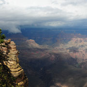
Der Grand Canyon liegt im Staat Arizona. Er erstreckt sich von Nordosten nach Westen. Über den Grand Canyon gibt es keine Brücken, Süd- und Nordufer (South- & North Rim) des Colorados sind auf Straßen nur östlich des Nationalparks Page oder rund 400 km weiter im Westen über Nevada verbunden. Der South-Rim ist von Flagstaff zugänglich, der North-Rim ist nur wenig besiedelt. Der Grand Canyon ist ca. 450 km lang , zwischen 6 und 30 km breit und bis zu 1800 m tief.
Die Dimensionen sind so groß, da man Menschen eigentlich gar nicht auf den Photos erkennen kann.
The Grand Canyon lies in the State of Arizona. It extends from northeast to the west. Over the Grand Canyon does not give it bridges, South & North Rim of the Colorados can only passed on roads east the national park Page or approximately 400 km further in the west by Nevada connected on roads. The South Rim is accessible from Flagstaff, which is North Rim only few settled. The Grand Canyon is approx. 450 km long, between 6 and 30 km broad and up to 1800 m deeply.
The dimensions are so large, since one cannot actually at all recognize humans in the photos.